Exploring the Great Smoky Mountains National Park: A Road Trip Adventure

Exploring the Great Smoky Mountains National Park: A Road Trip Adventure

Are you ready for an unforgettable road trip through the stunning landscapes of the Great Smoky Mountains National Park? Starting in Dillsboro, NC, this journey will take you on a thrilling adventure as you visit some of the most iconic attractions in the area. From the rich Native American heritage to breathtaking waterfalls and panoramic mountain views, there’s something for everyone to enjoy. So, buckle up and get ready to explore the wonders of this magnificent national park.

See our Interactive Map on Roadtrippers.com

Using out interactive map you can select the sites and activities that you want to see.  It’s a great way to plan your day(s) for this incredible journey. 

Great Smoky Mountains National Park & Tail of the Dragon Loop on Roadtrippers
Road trip to the Smoky Mountains

1. Oconaluftee Indian Village: A Glimpse into Native American Culture

Begin your road trip by immersing yourself in the rich Native American history at the Oconaluftee Indian Village. Located near the entrance of the Great Smoky Mountains National Park, this living history museum offers a fascinating glimpse into the lives and traditions of the Cherokee people.  Learn More

As you wander through the village, you’ll have the opportunity to interact with skilled artisans, learn about traditional crafts, and witness captivating cultural demonstrations. From pottery and basket weaving to storytelling and dance performances, every aspect of Cherokee life is beautifully showcased here.

2. Cherokee Indian Museum: Unraveling the Past

Continue your exploration of Cherokee culture at the Cherokee Indian Museum. Located in Cherokee, NC, this museum is dedicated to preserving and sharing the history, art, and traditions of the Cherokee people.

Step inside and embark on a journey through time as you discover exhibits that highlight the tribe’s past, including their struggles, triumphs, and contributions to the region. From ancient artifacts and traditional clothing to interactive displays and multimedia presentations, the museum offers a comprehensive understanding of the Cherokee heritage.

Cherokee 3

3. Mingo Falls: A Majestic Cascade

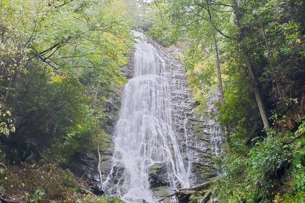
No road trip through the Great Smoky Mountains would be complete without a visit to Mingo Falls. Located within the Qualla Boundary, this breathtaking waterfall is a true hidden gem.

As you make your way to the falls, be prepared for a short but rewarding hike. The trail winds through lush forests and crosses over wooden bridges, offering glimpses of the cascading water along the way. Once you reach the base of Mingo Falls, you’ll be greeted by a magnificent 120-foot cascade that will leave you in awe.
Road trip to the Smoky Mountains
Mingo Falls, NC

4. Clingmans Dome: A Panoramic Mountain Experience

For a bird’s-eye view of the Great Smoky Mountains, head to Clingmans Dome. As the highest point in the national park, this iconic observation tower offers unparalleled panoramic vistas.

The journey to Clingmans Dome is an adventure in itself, as you drive along the scenic Newfound Gap Road. Once you reach the parking area, a short but steep paved trail will lead you to the observation tower. As you ascend, take your time to soak in the breathtaking beauty of the surrounding mountains and valleys.
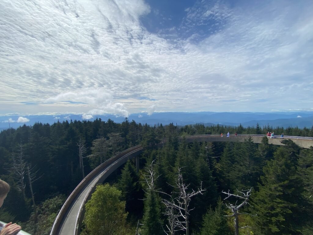
Clingmans Dome Road trip to the Smoky Mountains

5. Gatlinburg, TN: Gateway to Adventure

After immersing yourself in the natural wonders of the Great Smoky Mountains, it’s time to visit Gatlinburg, TN. Known as the gateway to the national park, this charming mountain town offers a wide array of attractions and activities.

Stroll along the bustling streets of downtown Gatlinburg, where you’ll find an abundance of shops, restaurants, and entertainment options. From unique boutiques and artisanal craft stores to delicious eateries and live music venues, there’s something to suit every taste.

1209 Gatlingburg Tennesse Road trip to the Smoky Mountains

6. Tail of the Dragon: A Thrilling Drive

For those seeking an adrenaline rush, no road trip through the Great Smoky Mountains is complete without driving through the Tail of the Dragon. This legendary stretch of road, also known as US Route 129, is famous for its 318 curves in just 11 miles.

As you navigate the twists and turns of the Tail of the Dragon, be prepared for a thrilling and exhilarating experience. The scenic beauty of the surrounding mountains combined with the adrenaline-inducing drive makes this a must-do for any road trip enthusiast.

Click for more maps and fun roads

Tail Of The Dragon Road trip to the Smoky Mountains

7. Mountain Layers Brewing: A Refreshing Finale

After a day of exploration and adventure, it’s time to unwind and relax with a cold brew at Mountain Layers Brewing in Bryson City, NC. This local craft brewery offers a wide selection of delicious beers, each crafted with passion and expertise.

Whether you prefer a hoppy IPA, a smooth lager, or a rich stout, Mountain Layers Brewing has something to satisfy every beer lover’s palate. Sit back, enjoy the laid-back atmosphere, and toast to a successful road trip through the Great Smoky Mountains National Park.

Mountain Layers Brewing

Conclusion

A road trip through the Great Smoky Mountains National Park is a truly unforgettable experience. From immersing yourself in Native American culture to marveling at majestic waterfalls and panoramic mountain views, this adventure offers something for everyone.

So, pack your bags, buckle up, and get ready to embark on a journey through the wonders of the Great Smoky Mountains. From Dillsboro to Bryson City, each stop along the way will leave you with memories that will last a lifetime.

Book Roamer's Respite Direct

Online platforms like Airbnb, VRBO, Booking.com and others, charge both the guest and the host a 15-25% commission fee for using those services.  That equates to hundreds of dollars of additional fees for a single rental.  Here at Roamer’s Respite, we don’t have those added fees and we pass the savings directly to our guests.  
Book Roamer's Respite Today

Book direct and save on commissions and fees.

Exploring Nature’s Beauty: Hiking trails in the Smoky Mountains

Hiking Trails in the Great Smoky Mountains National Park

GSMNP is a Hikers Paradise with More Than 800 Miles of Hiking Trails

The Great Smoky Mountains National Park (GSMNP) covers 522,427 acres and is divided almost evenly between North Carolina and Tennessee. It is estimated that in 2022 there were 13 million visitors to the GSMNP making it the 2nd most visited national park just behind the Blue Ridge Parkway, and both of these are just minutes out the front door of Roamer’s Respite in Sylva, NC.

With over 800 miles of hiking trails you are sure find and adventure that you’ll remember for a lifetime.  The closest access from Roamer’s Respite to the GSMNP is through Cherokee via Highway 441 known as Newfound Gap Rd.  In this post we are going to explore a few of the hiking trails that you can access directly from Newfound Gap Rd.   Download a PDF of the Great Smoky Mountains Trail Map.

New:  Parking tags are required to park in the Great Smoky Mountains National Park. Three tag durations will be available for purchase for all vehicle sizes and types: Daily, $5; Weekly, $15; or Annual, $40. Parking tags may be purchased online, or on-site. Parking tags will NOT be required for motorists who pass through the area or who park for less than 15 minutes, or while parked at their designated campsite. Parking Info

Leave No Trace

If you are here reading this, then I am sure you too love to be outdoors exploring all that nature has to offer.  No matter what activity you are enjoying outdoors, there is an inherent responsibility to protect our natural resources now and into the future. We hope that all outdoor enthusiasts will adopt responsible practices while taking in the enjoyment of nature.  

Below are 7 Leave No Trace Principles

  1. Plan Ahead and Prepare
  2. Travel and Camp on Durable Surfaces
  3. Dispose of Waste Properly
  4. Leave What You Find. 
  5. Minimize Campfire Impacts. 
  6. Respect Wildlife.
  7. Be Considerate of Other Visitors. 

Learn More about Leave No Trace at any of the following links. 

National Park Service

Leave No Trace Organization

Mingus Mill and Mingus Creek Trails

Length: 5.9 Miles
Elevation Gain: 1,509 ft
Route Type: Out & Back
Time: 3hr 17Min
Dogs: Not Allowed
Difficulty: Moderate

The Mingus Creek Trail, starting from the parking area of the historic Mingus Mill, offers a captivating hiking experience. Before beginning the hike, make sure to visit the mill, built in 1886, which operates using a unique water-powered cast iron turbine. You can tour the mill and purchase cornmeal ground on-site from mid-March to mid-November.

Named after John Jacob Mingus, the first Euro-American settler in the Oconaluftee valley, the trail diverts water from Mingus Creek after a short distance. Along the first mile, which was built by the Civilian Conservation Corps in the 1930s, you’ll pass through a pleasant new-growth forest with rhododendrons and various wildflowers.

The Mingus Creek Trail is part of the Mountains-to-Sea Trail, spanning about 1,150 miles from Clingmans Dome to Jockey’s Ridge on the North Carolina coast. After an easy mile, the trail becomes narrower and rockier. You’ll encounter footbridges, a fork leading to an old cemetery, and a creek crossing that may be challenging during heavy rain.

As the trail climbs higher, switchbacks take you to Deeplow Gap at 2.9 miles. While there are some views of the surrounding mountains before the trees leaf out in spring, they aren’t particularly noteworthy. At this point, you have the option to take the Deeplow Gap Trail down to Cooper Creek Trail or Thomas Divide Trail. Alternatively, you can continue on the Mingus Creek Trail towards Newton Bald, adding another 2.8 miles and 1460 feet of climbing to your hike.

The Mingus Creek Trail invites you to discover the historical mill, enjoy a diverse natural environment, and challenge yourself with rewarding climbs. Take in the scenic beauty of the Great Smoky Mountains National Park and create lasting memories along this captivating trail.

The 18 mile drive will only take you 26 minutes from Roamer’s Respite Vacation Home. 

Smokemont Loop / Bradely Fork Trail

Length: 6.5 Miles
Elevation Gain: 1,441 ft
Route Type: Loop
Time: 3hr 10Min
Dogs: Not Allowed
Difficulty: Moderate

The Smokemont Loop Trail is a picturesque 6.5-mile circuit that winds through lush forests, beside babbling streams, and past breathtaking vistas. As you embark on this journey, be prepared to immerse yourself in the sights and sounds of nature, surrounded by towering trees and the harmonious melodies of chirping birds.

The trail begins at the Smokemont Campground, where you’ll find ample parking and facilities. From there, the path leads you on a captivating expedition, gradually ascending through the dense woodland. Along the way, you’ll encounter an array of wildflowers, adding vibrant colors to the verdant landscape.

One of the highlights of this trail is the opportunity to witness an abundance of wildlife. Keep your eyes peeled for deer gracefully grazing in meadows or squirrels playfully darting through the branches above. If you’re lucky, you might even catch a glimpse of a black bear or a majestic elk, adding an extra touch of excitement to your adventure.

As you reach the latter part of the loop, the trail begins its descent, leading you back to the starting point. The journey may be coming to an end, but the memories and awe-inspiring experiences will stay with you long after you leave.

The 21 mile drive will only take you 34 minutes from Roamer’s Respite Vacation Home. 

Clingmans Dome Observation Trail

Length: 1.3 Miles
Elevation Gain: 337 ft
Route Type: Out & Back
Time: 1 hr
Dogs: Not Allowed
Difficulty: Moderate

The Great Smoky Mountains are home to an array of natural wonders, and one of the most captivating destinations within this majestic range is Clingmans Dome. This iconic peak offers breathtaking panoramic views, unique hiking experiences, and the opportunity to immerse yourself in the beauty of nature. 

Clingmans Dome, located in the heart of the Great Smoky Mountains National Park, straddles the border between Tennessee and North Carolina. It is the highest point in the Smokies, standing tall at an elevation of 6,643 feet (2,025 meters). The dome itself is a remarkable geological formation, shaped by millions of years of natural forces.

The Clingmans Dome Trail is a paved pathway that spans approximately 0.5 miles (0.8 kilometers) from the parking area to the observation tower.

The highlight of visiting Clingmans Dome is undoubtedly the observation tower. As you ascend the spiral ramp, anticipation builds, and once at the top, the breathtaking vistas make it all worthwhile. The panoramic views allow you

The 40 mile drive will only take you 1 hour from Roamer’s Respite Vacation Home. 

Clingmans Dome to Andrews Bald

Length: 3.6 Miles
Elevation Gain: 875 ft
Route Type: Out & Back
Time: 2 hr
Dogs: Not Allowed
Difficulty: Moderate

The Forney Ridge Trail offers a thrilling trek that covers 1.8 miles of the 5.6-mile trail, leading you from the Clingman’s Dome parking lot to the awe-inspiring Andrew’s Bald. With breathtaking views of the Great Smoky Mountains and the opportunity to witness the beauty of bald mountaintops, this hike promises an exhilarating experience for nature enthusiasts of all levels.

As you arrive at the end of Clingman’s Dome Road, you’ll find the Forney Ridge Trailhead nestled at the final stretch of the parking lot. Begin your adventure by setting foot on this scenic path that leads you through a vibrant woodland. For the first mile, the trail gently descends, offering a serene journey surrounded by the natural wonders of the park. However, be prepared for sections of the trail that are strewn with rocks, adding an element of challenge to your hike.

Upon reaching Andrew’s Bald, prepare to be mesmerized by the panoramic vistas that unfold before your eyes. Behold the splendor of the southern half of the park, with its sprawling beauty extending as far as the eye can see. From this vantage point, you’ll be treated to awe-inspiring views of the Great Smoky Mountains and the glistening Fontana Lake. Take a moment to soak in the tranquility and grandeur of nature.

After immersing yourself in the beauty of Andrew’s Bald, you have a choice to make for your return journey. You can retrace your steps and head back to Clingman’s Dome, completing a 3.6-mile hike in total. This option offers a chance to revisit the stunning landscapes you encountered earlier in the day.

Alternatively, if you’re up for a more adventurous and physically demanding challenge, you can continue your hike down the Forney Ridge Trail. The trail stretches nearly four more miles along the ridge, providing a steep and invigorating return trip. Be prepared for the rugged terrain and the test it presents to your hiking prowess.

The 40 mile drive will only take you 1 hour from Roamer’s Respite Vacation Home. 

Other Notable Hiking Trails in the GSMNP

Deep Creek Loop

This route includes both the Deep Creek Trail and the Indian Creek Trails. It is a 4 mile, easy to moderate journey.  A very highly rated trail by many hikers, you will some great waterfalls and have a great time on this trail.  

Deep Creek Trail

If you have a vision of one of the best hikes in the Smokies then this would be it.  If you like streams, wildflowers, birds chirping and a longer hike this is definitely it.  I wouldn’t recommend this if heavy rain is expected as it can become quite wet and the creek crossings can be tricky. 

Noland Divide Trail to Lonesome Pine Overlook

The 6.7-mile hike round trip offers breathtaking views despite its challenging nature. The trail begins at the horse trailer parking area across from the Deep Creek campground, just inside the Deep Creek park entrance. The initial three-mile stretch involves a significant elevation gain of 2300 feet. Upon reaching the pinnacle of Beauregard Ridge, the trail transforms into a narrow razorback path, treating hikers to panoramic vistas of Bryson City, the Tuckasegee Valley, and the majestic Nantahala Mountains in the distance.

The Great Smoky Mountains: Your hiking paradise

Within the vast expanse of the Great Smoky Mountains National Park, an extensive network of over 800 miles of trails awaits, presenting a plethora of opportunities for exploration. Amidst this natural splendor lies the promise of an unforgettable experience—an indelible hike, a transformative moment that weaves itself into the tapestry of your memories. The resplendent beauty of the surrounding landscape is a precious gift, a testament to the intricate marvels of the natural world. As you venture into the untamed wilderness, I implore you to embrace the profound depth of these encounters, allowing them to permeate your very essence, leaving an enduring imprint on the very fabric of your soul.

North Carolina’s Thrilling Winding Mountain Roads

- The Road to adventure is paved with curiosity -

Rev your engines and prepare for the ultimate adventure on the Western North Carolina thrilling winding mountain roads! This picturesque region boasts some of the most breathtaking and exhilarating routes on the planet. Feel the rush as you navigate the legendary Blue Ridge Parkway, a paradise that guarantees unparalleled thrills. 

For those seeking off-the-beaten-path excitement, explore the hidden gems and winding back roads of Cashiers, Cherokee, Dillsboro, and Sylva. These vibrant mountain towns serve as ideal base camps for your adrenaline-fueled escapades. Get ready to conquer the open road and create unforgettable motorcycling memories in Western North Carolina!

Often overlooked by riders, Jackson County in the Western North Carolina mountains offers a plethora of rider-friendly, lesser-traveled back roads. This hidden gem provides convenient access to the Great Smoky Mountains National Park and a larger section of the awe-inspiring Blue Ridge Parkway than any other county in the state. Situated centrally, it’s an ideal base for riders to make the most of their visit, spending less time in traffic and more time exploring the magnificent mountain vistas. Discover this motorcyclist’s guide, featuring recommended routes from local riders, and get ready to embark on your next thrilling adventure in the Western North Carolina mountains!

Distance: 162 Miles 

Full-day journey

This is 4 hours without stops, but you are going to want to stop plenty.  Enhancing the thrill of the iconic Tail of the Dragon, the exhilarating Explorer loop awaits. Prepare to embark on an unforgettable journey through two states, immersing yourself in the awe-inspiring beauty of the Great Smoky Mountains National Park. Recommended by local riders, this full-day loop is designed to amplify the excitement already offered by the Tail of the Dragon. Get ready to elevate your adventure and create lasting memories as you conquer this remarkable route. Brace yourself for an experience like no other!

Distance: 55 Miles 

2 Hour journey

Cullowhee Mountain Road offers a true off-the-beaten path experience. Exclusively in Jackson County and recommended by local riders, this route provides riders a curvy back-road excursion spanning from Cullowhee and looping around N.C. 107 North back to Sylva.

Insider Tips:

  • Pines Recreation Area, 1965 Pine Creek Road, Cullowhee, NC 28723: Offering 26 miles of shoreline, 3 waterfalls, and place to take a rest, Lake Glenville is one of the highest elevated lakes east of the Mississippi. The Pines Recreation Area amenities includes a sandy swimming beach with plenty of parking for multiple bikes, restrooms, and picnic benches to eat a packed lunch.
  • Cashiers, North Carolina, 6 N.C. 107, Cashiers, NC 28717: The
    mountain town of Cashiers, North Carolina is accessible on this
    route by heading South on N.C. 107 (right turn), instead of North, for approximately 6.5 miles. Cashiers is home to upscale shopping, dining, and quaint southern charm. It also hosts The Village Green, a relaxing commons/park area worthy of exploration.
  • Gravel Driveways: Proceed with caution on this route. Many
    driveways along both Cullowhee Mountain Road and N.C. 107 are unpaved, and gravel and will occasionally wash out into the road.

Distance: 158 Miles

Full-day journey

Prepare for the ultimate thrill on America’s beloved two-lane touring road, the legendary Tail of the Dragon. With an astounding 318 curves packed into just 11 miles, this iconic route is an experience that defies expectations. Located a scenic hour’s drive from Sylva, it beckons riders & drivers seeking a full day of heart-pounding adventure. Embark on this exhilarating journey and test your skills on this technical motoring masterpiece. Brace yourself for an experience that will leave you breathless and create memories that will last a lifetime.

Insider Tips:

  • Curves are incredibly sharp, heed posted warning signs at all times.  Stay in your lane, do not pass, and do not exceed posted limits.
  • Picture Perfect: motorists taking on the Tail of the Dragon are photographed by killboy.com. Photographers are set up at various corners on the road and pictures are available for purchase online the day after your ride.
  • The Best Way to End a Full Day: Returning to Sylva/Dillsboro, riders will find a wide variety of dining options ranging from biker-friendly bars to elevated farm-to-table restaurants, and over 120 taps at our breweries to satisfy a long day’s ride.

Distance: 141 Miles

Full-day journey

Embark on an epic journey with one of the longest and most diverse routes, spanning through captivating destinations such as Sylva, Cashiers, Brevard, the Blue Ridge Parkway, Maggie Valley, and Cherokee. This remarkable route offers a little bit of everything, and it can be customized to suit the preferences of each rider. However, it’s important to note that this route is a full-day adventure, featuring multiple thrilling twisty back roads, breathtaking mountain passes, and awe-inspiring scenic vistas along the way. Get ready to immerse yourself in the ultimate exploration of Western North Carolina’s captivating landscapes.

Distance: 126 Miles

Full-day journey

Embark on an epic journey with one of the longest and most diverse routes, spanning through captivating destinations such as Sylva, Cashiers, Brevard, the Blue Ridge Parkway, Maggie Valley, and Cherokee. This remarkable route offers a little bit of everything, and it can be customized to suit the preferences of each rider. However, it’s important to note that this route is a full-day adventure, featuring multiple thrilling twisty back roads, breathtaking mountain passes, and awe-inspiring scenic vistas along the way. Get ready to immerse yourself in the ultimate exploration of Western North Carolina’s captivating landscapes.

Distance: 68 Miles 

Half-day journey

Discover the enchanting Scenic Jackson, a captivating loop that transforms your Blue Ridge Parkway experience into a picturesque journey back to Sylva through eastern Jackson County via Charleys Creek Road (S.R. 1756). Along this route, you’ll traverse five tributaries of the Tuckasegee River’s East Fork – Tanassee Creek, Wolf Creek, Gage Creek, Charleys Creek, and Sols Creek – while immersing yourself in pastoral scenes and breathtaking mountain vistas. Don’t miss the landmarks that dot the way, including Richland Balsam, the highest point on the Blue Ridge Parkway, a glimpse of the majestic 5,574-foot Charley Bald, and the inviting Balsam Lake. Take a moment to relax and rejuvenate at the U.S. Forest Service picnic area, complete with public restrooms. Scenic Jackson beckons, promising an unforgettable journey through nature’s wonders.

Distance: 67 Miles

Half-day journey

This route will take you past 3 of the region’s best: Wolf Lake, Lake Toxaway, and Lake Glenville, and makes for a relaxing, enjoyable half-day ride.

Insider Tips: Pack a lunch: This route is a true half-day route. Considering the route’s secluded nature, local riders recommend packing a lunch or a snack to enjoy along the way. There is a gas station near the
N.C. 107/N.C. 281 intersection but no other gas stations before reaching Cashiers

Distance: 98 Miles

3/4 day journey

This loop will take you from Sylva to Cherokee… and
everywhere in between. Starting and ending in Sylva, riders will experience the best of the Blue Ridge Parkway, some back-road farmlands, and gives you the option to explore Harrah’s Cherokee Casino.

Insider Tips:

  • Wheels Through Time Museum, 62 Vintage Lane Maggie Valley, North Carolina 28751: Home to the world’s premier collection of rare American motorcycles, memorabilia, and a distinct array of “one-off” automobiles, the Wheels Through Time Museum is a must-see. Operating hours Thursday-Monday, 9am-5pm.
  • Best BRP Views heading north: Riding on the Blue Ridge Parkway gives riders the opportunity to see some truly spectacular views along the way. With many named pull-offs along this route, riders are encouraged to check out Cowee Mountain Overlook, Richland Balsam, and Devil’s Courthouse. Richland Balsam is the highest point along the BRP standing at 6,053 feet and is a favorite for riders to take pictures. Cowee Mountain Overlook offers a fully
    panoramic view and is regularly among the best places to catch a sunset in the N.C. Mountains while the Devil’s Courthouse pull off is a great opportunity to stretch your legs and hike a short trail to an amazing view

Distance: 98 Miles

3/4 day journey

Immerse yourself in the unparalleled beauty of the Blue Ridge Parkway, renowned as America’s most celebrated motor route. This haven for motor enthusiast’s is a true mecca, boasting sweeping scenic vistas, exhilarating curves, and convenient overlooks that offer breathtaking views. Jackson County takes pride in being home to more of the Blue Ridge Parkway than any other county, allowing riders to fully indulge in this pristine ride. Embark on the following route, designed to begin from the captivating towns of Sylva and Dillsboro, and bring you back to the same location, ensuring a seamless and unforgettable adventure through the heart of the Blue Ridge Parkway.

Insider Tips:

  • Overlooks: Along this route, there are many overlooks, each offering a unique view of the Blue Ridge Mountains. Among them is
    Waterrock Knob, which offers an ideal place for riders to rest and take a picnic. Waterrock Knob’s amenities include restrooms, a gift
    shop, a large parking area, picnic benches and even a short hike to one of the highest points and best views along the Blue Ridge Parkway.
  • Riders will want to make sure that they are
    stocked up on supplies and fuel because there are few restaurants or gas stations along this route. If either is needed, proceed back to Cherokee before continuing on the Blue Ridge Parkway portion of this ride.

When on the road, it can be imperative to know where you can get trusted maintenance services. We’ve compiled a list of  regional repair and service shops that can help keep you traveling.

Jackson County offers a large rider friendly atmosphere, with many restaurants, breweries, and attractions that will cater well to
any size group of riders: